Maps & plans


A quick, and very rough sketch to show the levels. That it looks like part of Ricey’s Cornfield Street is no accident – it fits the bill perfectly, so there’s no need to reinvent the wheel.

Rough sketch of The Yard

We’re looking south. In the foreground I’ve added the an impression of the far side of the brick lined cutting for the Met Lines (stage 3 of this segment) and the position of the future road bridge over it on the right hand side. On the viaduct at the back will be the quadruple tracks of the GE Main and Through lines with the beginnings of some sidings on the left (stage 2). These three stages will only encompass one half of The Rookery with about half as much again either side bringing the Rookery to about 20′ in length. However, what you see here shows the extent of the visible Met lines for this whole section as they disappear into cut & cover tunnels either side. Over the top on the right (west, towards The City) will be a network of grimy East End streets and courtyards with the main lines on the GE viaduct forming the backdrop. Beyond that is a goods depot and then Artillery Lane where the Met lines reappear. To the left the sidings eventually lead to a large coal depot. But that’s all some way off…

In the space in the left foreground are some dilapidated buildings of a small courtyard (H. Dowling & Sons, Decorators, perhaps?) accessed through the viaduct. It all looks to be a tight squeeze and that’s intentional; I want to impart a cramped, claustrophobic feel. I think a mock up will be essential so I can move things around if necessary to make the best of it.

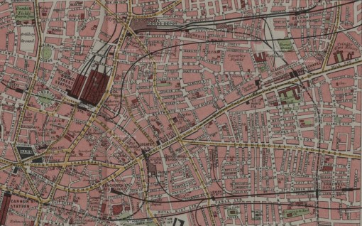
Continuing on from my earlier post , I thought it might be an idea to show how the Extended Circle & Widened Lines, and the East London Railway Extension with the new Thames Tunnel all fits into the geography of East London.

If you’ve read the earlier post you will know how the Extended Lines branch off from the Inner Circle just after Bishopsgate (Liverpool Street), and here you can see the Extended Circle and Widened Lines pushing east as far as Bow before heading south towards the river where there was a junction for the New Thames Tunnel at Limehouse. The Extended Circle and Extended Widened Lines finally headed west, past the docks to Mark Lane, while the new tunnel took the line under the Thames and the Surrey Commercial Docks to Deptford Road, where the line rejoined the ELR to New Cross. For clarity I’ve only marked the Basilica Fields stations on the map (both the GER and Metropolitan ones), but there are other stations on the Metropolitan line which I’ll describe later. For the same reason I’ve omitted the goods depots which will be covered in subsequent posts.

As an aside, welcome to new readers. Unique hits almost doubled yesterday, with almost 100 different visitors which I find staggering.

Passenger services from three companies originating south of the Thames will feature on Basilica Fields, viz; the London Brighton and South Coast Railway, the South Eastern Railway, and the London Chatham and Dover Railway. The latter, known as the East Kent Railway until 1859, was empowered under the Metropolitan Extension Act of 1860 to build a line from Beckenham to Herne Hill where a junction took a line north west to Victoria, and another due north towards the then projected Metropolitan Railway at Farringdon Street (then known as Victoria Street). The line to Victoria was complete three years later, and the City line was opened as far as Blackfriars Bridge in June 1864. Within six months the line had crossed the Thames to a temporary station, Ludgate Hill, but the final stretch from there to an end-on junction with the Metropolitan at West Street took considerably longer as it fell foul of inspections by the Board of Trade, and it wasn’t until the beginning of 1866 that all objections were satisfied, and the line opened.

LCDR services from Ludgate Hill to the GNR terminus at Kings Cross and back commenced immediately, and within two days the GNR was itself running trains between the two stations. Eventually the long arm of the LCDR reached into both Middlesex via the GNR and Midland, and Hertfordshire, with services from Victoria or Herne Hill to destinations such as Hatfield, Enfield, Kentish Town, Hendon, and Alexandra Palace.

Key to Basilica Fields, a eastwards spur between Snow Hill and the Great Western Railway’s depot at Smithfield was proposed, to which the BoT objected, due to the safety aspect of the flat crossing between the spur and the outward line from the depot. After much petitioning, the BoT relented, and the spur was eventually sanctioned in 1871, so Moorgate Street became an alternative destination for the Chatham until the Extended Circle was rolled out in the late 1880s, and Basilica Fields became the terminus for Chatham trains.

The RCH Junction diagram from the turn of the century shows the relationship between the Chatham, the Metropolitan and the Widened Lines companies, although as the diagram is dated post-1899, the Chatham line comes under the aegis of the SECR Committee.

Graham’s comment to yesterday’s post raised the question of the angle in the viaduct. If you click the image above you’ll have a clearer picture of the GER’s massive goods depot – and this is without the transfer sidings and enormous coal viaducts a few hundred yards east.

The drawing shows the two rail-served levels at Bishopsgate. The upper drawing shows the plan at viaduct level, and the lower shows the street level with sub-surface lines marked on too. The angle in the brickwork which Graham queried in yesterday’s photo signifies the beginning of the northernmost siding of the yard (or field as the GE would have it) which served the ‘Continental Bank’ – one of the outer banks or platforms at the depot. It was so named as it was originally for continental traffic received from and sent to Harwich and Parkston Quay. The drawing must be dated post-1909 as St. John Street was been renamed Grimsby Street that year, and the position of the angle in the viaduct is clear.

Two photographs on this page give an idea of how things looked. The first photo looks out from the warehouse onto the field, and the housing on the left in the middle distance mark St. John (Grimsby) Street. The third photo shows the covered Continental Bank.

[edit] I won’t be modelling Bishopsgate Depot!

Departing  Moorgate Street in an easterly direction, beneath Finsbury Circus, the Extended Widened Lines descended to a level deeper than the adjacent Metropolitan line, so that at Bishopsgate, the Extended Widened Lines’ platforms were underground. After crossing Bishopsgate Street, the Extended Widened Lines swept north,  passing underneath the Metropolitan line, and followed the Eastern Circle Extension which had itself branched off at Devonshire Square Junction.  Civil Engineering issues prohibited the Extended Widened Lines from crossing under the Eastern Circle until the tracks had cleared the tunnels under the Katherine Docks Warehouses, which was then achieved by a gridiron flyover at Artillery Lane. Both lines then plunged into a cut and cover section to cross the area between Commercial Road and Cambridge Road which included Great Eastern Railway’s massive Spitalfields/Whitechapel coal depot and the East London Railway formation. The end of the Eastern Circle can also be seen as it follows Cable Street and Mint Street to rejoin the Metropolitan and District at Mark Lane.

Next Page »